
|
Generated on 7/31/2025 at 8:56 AM |
The webpage this document was printed/exported from can be found at the following URL:
https://www.cpalms.org//PreviewStandard/Preview/15693
https://www.cpalms.org//PreviewStandard/Preview/15693
Use coordinate geometry to solve mathematical and real-world problems on the coordinate plane involving perimeter or area of polygons.
Standard #: MA.912.GR.3.4
Standard Information
Standard Examples
Example: A new community garden has four corners. Starting at the first corner and working counterclockwise, the second corner is 200 feet east, the third corner is 150 feet north of the second corner and the fourth corner is 100 feet west of the third corner. Represent the garden in the coordinate plane, and determine how much fence is needed for the perimeter of the garden and determine the total area of the garden.
General Information
Subject Area: Mathematics (B.E.S.T.)
Grade: 912
Strand: Geometric Reasoning
Date Adopted or Revised: 08/20
Status: State Board Approved
Standard Instructional Guide
Connecting Benchmarks/Horizontal Alignment
Terms from the K-12 Glossary
- Area
- Perimeter
- Polygon
Vertical Alignment
Previous Benchmarks
Next Benchmarks
Purpose and Instructional Strategies
In elementary grades, students are introduced to the concepts of perimeter and area, with a focus on rectangles. In middle grades, students expand their knowledge of areas of quadrilaterals and triangles. In Geometry, students find perimeter and area of two-dimensional polygons on the coordinate plane. In later courses, students develop further tools for finding area, especially using calculus.- Instruction includes discussing the convenience of answering with exact values (e.g., the simplest radical form) or with approximations (e.g., rounding to the nearest tenth or hundredth). It is also important to explore the consequences of rounding partial answers on the accuracy or precision of the final answer, especially when working in real-world contexts.
- Problem types include polygons that are convex (where all interior angle measures are less than 180 degrees), concave (where at least one interior angle measure is more than 180 degrees), regular polygons (where all interior angle measures and side lengths are equivalent) and irregular polygons.
- Instruction includes the use of the distance formula and the Pythagorean Theorem to find side lengths of the polygon in order to determine the perimeter or area.
- Instruction includes various methods to determine area on the coordinate plane.
- Decomposition
- Students can decompose the polygon into triangles and rectangles (or other quadrilaterals) to determine the total area by adding each of the partial areas.
- Subtraction Method (Box Method)
- Students can draw a rectangle that includes as many vertices of the polygon as possible and then to determine the area of the polygon, subtract the area(s) of the shape(s) that is (are) in the “box” but not in the polygon from the area of the rectangle.
- For possible enrichment, other methods include, but are not limited to, Pick’s Theorem or the Shoelace method.
- Decomposition
- Refer to Appendix E for formulas of two-dimensional figures. It may be helpful to review the derivation of these formulas, as this was done in middle grades.
Common Misconceptions or Errors
- Students may confuse the concepts of area and perimeter.
- Students may assume that the larger the area a polygon has, the larger its perimeter will
be.
- For example, a rectangle may have an area of 64 square meters and could have a perimeter of 32 meters or any perimeter larger than 32 meters.
Instructional Tasks
Instructional Task 1 (MTR.3.1, MTR.6.1)- Given parallelogram EFGH with vertices E(−1, 5), F(2, 8), G(4, 4) and H(1, 1).
- Part A. Find the exact perimeter and area of the parallelogram.
- Part B. Find the perimeter and area of the parallelogram to the nearest tenth.
- Joe’s commute to work can be represented in the coordinate plane as follows:
- His house is at H(0,0).
- His favorite coffee shop is at C(7, 6) where he stops every morning.
- His office is at W(4, 13).
- He goes back home from his office every day without stopping.
- Part A. Assume that Joe lives in a city where the roads are parallel to the coordinate axes and each intersection occurs at integer coordinates. Represent his route on the coordinate plane where each city block is one coordinate unit by one coordinate unit, which measures 175 yards by 175 yards.
- Part B. What is the total distance, in yards, that Joe commutes every day, assuming that he stays on the roads?
- Part C. If Joe could take the most direct route (cutting across city blocks) for his commute, what would be his total distance, in yards, that he commutes every day?
Instructional Items
Instructional Item 1- The Move With Us Run Team is planning a run around the combined perimeter of Polk and
Osceola counties (as shown by the green rectangle).
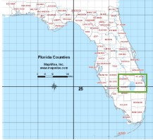
- Part A. What are the coordinates of the four vertices that could be used to measure the run around the two counties? Use the scale provided on the map to determine the coordinates.
- Part B. Using the coordinates found in Part A, what would be the total distance of the run, in miles?
- Part C. Assume that the group runs a total of 10 miles every day, how many days would it take them to complete the distance around the two counties?
Related Courses
- Foundational Skills in Mathematics 9-12 (Specifically in versions: 2014 - 2015, 2015 - 2022, 2022 - 2024, 2024 and beyond (current)) # 1200400
- Geometry (Specifically in versions: 2014 - 2015, 2015 - 2022, 2022 - 2024, 2024 and beyond (current)) # 1206310
- Geometry Honors (Specifically in versions: 2014 - 2015, 2015 - 2022, 2022 - 2024, 2024 and beyond (current)) # 1206320
- Geometry for Credit Recovery (Specifically in versions: 2014 - 2015, 2015 - 2022, 2022 - 2024, 2024 and beyond (current)) # 1206315
- Access Geometry (Specifically in versions: 2015 - 2022, 2022 and beyond (current)) # 7912065
Related Access Points
- MA.912.GR.3.AP.4 # Solve mathematical and/or real-world problems on the coordinate plane involving perimeter or area of a three- or four-sided polygon.
Related Resources
Formative Assessments
- Perimeter and Area of an Obtuse Triangle # Students are asked to find the perimeter and area of an obtuse triangle given in the coordinate plane.
- Perimeter and Area of a Right Triangle # Students are asked to find the perimeter and the area of a right triangle given in the coordinate plane.
- Perimeter and Area of a Rectangle # Students are asked to find the perimeter and the area of a rectangle given in the coordinate plane.
- Pentagon’s Perimeter # Students are asked to find the perimeter of a pentagon given in the coordinate plane.
Lesson Plans
- My Geometry Classroom # Students will learn how to find the area and perimeter of multiple polygons in the coordinate plane using the composition and decomposition methods, applying the Distance Formula and Pythagorean Theorem. Students will complete a Geometry Classroom Floor Plan group activity. Students will do a short presentation to discuss their results which leads to the realization that polygons with the same perimeter can have different areas. Students will also complete an independent practice and submit an exit ticket at the end of the lesson.
- Just Plane Ol' Area! # Students will construct various figures on coordinate planes and calculate the perimeter and area. Use of the Pythagorean theorem will be required.
Perspectives Video: Professional/Enthusiast
- Cataloging Cats with Cartesian Coordinates # <p>This researcher knows where your cat lives! Watch how he uses coordinates and the distance formula to plot the location of hundreds of thousands of cats on a map.</p>
Perspectives Video: Teaching Ideas
- Exploring the Hat Polygon # Unlock an effective teaching strategy for engaging students with the newly discovered hat polygon in this Teacher Perspectives video for educators.
- Finding the Area of a Polygon on the Coordinate Plane # Unlock an effective teaching strategy for finding the area of polygons on the coordinate plane using nontraditional methods in this Teacher Perspectives video for educators.
MFAS Formative Assessments
- Pentagon’s Perimeter # Students are asked to find the perimeter of a pentagon given in the coordinate plane.
- Perimeter and Area of a Rectangle # Students are asked to find the perimeter and the area of a rectangle given in the coordinate plane.
- Perimeter and Area of a Right Triangle # Students are asked to find the perimeter and the area of a right triangle given in the coordinate plane.
- Perimeter and Area of an Obtuse Triangle # Students are asked to find the perimeter and area of an obtuse triangle given in the coordinate plane.